Ground Based Scanning
Laser scanners measure thousands of three dimensional points a second producing a "point cloud" that can be used for dimensioning, retro-fitting, design, and the creation of virtual models.
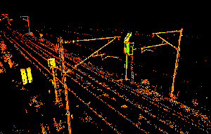
Modelling from Point Cloud Data
The point cloud data can be rendered to produce millimetric accurate virtual models. A focal point e.g. a substation can be scanned from several locations and these scans can be combined to produce a single "point cloud" for the site. Each component of the substation could then be extracted from the data dimensioned and rendered thus producing a virtual model of the complete site. Images can show the raw points e.g. for the main gantry consisting of several million individual points. These points where imported into MicroStation are rendered to produce the completed model.
For all of your GPS survey requirements, please contact us or email Brian Cairns at brianc@infrasafe.co.uk or on 0191 499 0024.